Mangrove in Australia ...[2]

Mangrove Zones


Different mangrove species have different requirements. Some are more tolerant of salt than others. They have different nutrition needs. The plants are affected by wave energy, soil oxygen levels, and drainage. When a species finds its preferred conditions, it becomes stronger and more plentiful than others. This has led to quite clear zones among mangroves.
The zones run parallel to the shore or to the banks of tidal creeks:

Along the sea side, there is generally an area of grey mangroves, best adapted to a wide range of soil conditions. It is a tough species, and is Australia's most common mangrove due to its ability to tolerate low temperatures and a variety of other intertidal conditions. It is generally the first to start growing on new mud banks, with its distinctive peg roots. The Mangrove apple often grows in this zone too.

The red mangrove, also known as the stilt or spider mangrove, is usually found behind this zone where its long prop roots anchor it in wind and waves.

The next zone is the part that is flooded only sometimes, at times of very high tides. The soil is firmer but saltier because of the irregular flooding: the water evaporates and leaves a coating of salt which does not get diluted until the next flooding. The yellow mangrove species are found in this zone. Conditions make it difficult for other species to survive here, other than saltmarshes or succulent plants.

Further zones can see the grey mangrove again, and in less salty soil there may be a thick forest of the orange mangrove species.

Local conditions dictate what is found on the land side. For example, in tropical areas there may be regular flooding and freshwater swamps with less salt tolerant plants. There may be a zone of paperbark swamps as vegetation merges into rainforest. In areas seasonal rainfall, evaporation could mean increased saltiness, so there may be a saltmarsh.

The richest mangrove communities are found in tropical and sub-tropical areas where the water temperature is over 24ÂșC in the warmest month, where the annual rainfall is more than 1250mm and high mountains are close to the coast, ensuring rainfall.

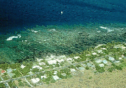
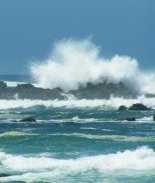
Mangroves need protection from high energy waves which erode the shore and prevent seedlings from becoming established.

Salt

Many mangroves stop much of the salt from entering their systems by filtering it out through their roots. Some species can keep out more than 90% of salt in sea water. Others quickly pass the salt out of their systems once it has entered. Their leaves have special salt glands which pass the salt out. You can see and taste the salt coating the leaves. Still others collect the salt in bark or in older leaves that are about to drop. Some mangroves use more than one of these methods.

Mangroves also have features that conserve water: thick waxy leaves, fleshy leaves, pores in the leaves that are sunken below the surface so that wind doesn't dry them out.

Do mangroves need salt?
Apparently not. Some species have been kept in pots where they have grown healthily and flowered regularly when given only fresh water. However, experiments have shown that the best growth occurs where the plants live in sea water diluted by about 50 per cent with fresh water.

Unstable Ground

Apart from the salt, mangroves also have to cope with being water-logged, and with unstable soils that may be lacking in oxygen. Mangrove plants have come up with quite similar ways of dealing with these difficulties:

Roots
Roots support a plant and take in essential nutrients and oxygen. In unstable soil an extensive root system is necessary in order for the trees to remain standing. Most mangroves have more of the plant below the ground than above it. The main mass of roots, however, is generally within the top two metres of the soil, as the oxygen supply is in that layer. Cable roots and anchor roots provide support. Small roots come from these to collect nutients from the rich surface soil. Other roots collect oxygen from the soil.

Because little oxygen is in the mud, many mangroves raise part of their roots above the surface. These roots are covered in special breathing cells to draw in air. To avoid getting buried in the build up of soil sediment, the breathing roots can grow up vertically. Pollution is a problem : oil blocks the breathing cells and the plant can suffocate.

Red, stilt or spider, mangrove is subjected to high wave action and has stilt or prop roots. These spread far and wide, providing numerous anchors for the tree as well as a large surface area for the breathing cells. Extra stilts can grow from the branches or trunk, and develop many breathing cells as soon as they reach the mud.

Grey mangrove grows peg roots, which act like snorkels. Orange mangrove develops cable roots which have grown above the surface of the mud and then down into it again. Looking glass mangrove has buttress roots which are like flattened, blade-like stilt roots.

Spreading new plants
The fruits and seedlings of all mangrove plants can float, which is how the plant sends its seeds away to grow in another area. Generally the seeds float away and lodge in mud, where they begin to grow. Some kinds will only germinate when temperatures or salt levels are satisfactory. Some species do not drop their seeds, but begin to grow out of the base of the fruits to form long spear-shaped stems and roots that grow, attached to the parent tree, for one to three years. They reach lengths of up to a metre before breaking off the parent plant and falling into the sea. They float horizontally until they can lodge in mud in a less salty place, where they turn vertically , roots down and buds up. They then begin to grow rapidly.

The cannonball mangrove produces a large fruit, about 20cm in diameter containing up to 18 tightly packed seeds. When ripe, it explodes and scatters the seeds, which float away on the sea. The seed of the looking-glass mangrove has a prominent ridge on one side. This can act as a sail when the seed is in the water. (source ... >>)

more.. »

Mangrove in Australia ... [1]

Mangroves are plants that live between the sea and the land, where they are flooded by tides. This is called the 'intertidal zone'. The word 'mangrove' is given to either an individual species(kind) of plant or to a group of unrelated plants, living in areas that are flooded by tides. So a mangrove may be a tree, shrub, palm, fern, climber or grass - all of them able to live in salt water.

Mangroves exist in a constantly changing environment. The sea regularly floods the area with salty water, and at low tide, especially during periods of high rainfall, there may be floods of fresh water. This quickly alters the salt levels, and can alter temperatures as well.

Importance of Mangroves

Mangrove trees are an important habitat for birds, mammals, crustaceans and fish by providing a breeding place and by giving protection. Mangroves improve water quality by filtering pollutants, stabilising and improving the soil and protecting shorelines from erosion.

Mangroves are an important part of the food chain for a number of animal species. Mangrove plants produce a large amount of litter such as leaves, twigs. bark, fruit and flowers. Some of this immediately becomes food for creatures such as crabs, but most breaks down before being consumed by other creatures. Bacteria and fungi break down the litter, increasing its protein, making it into food for fish and prawns. They in turn produce waste which, along with the even smaller mangrove litter, is eaten by molluscs and small crustaceans. Even dissolved substances are consumed by plankton or, if they land on the mud surface, by animals such as crabs and mud whelks.Every time the tide goes out, it takes with it carries a great deal of food out to sea, as much as 12,500 tonnes each year. This is dropped over a huge area of the seabed, and feed bottom dwellers, prawns and fish.

Mangrove Uses

Mangroves are rich in resources. Fish, crabs,shellfish, prawns and edible snakes and worms are found there. The fruit and the nectar of some plants, including the Nypa palm, can be eaten after preparation. The best honey is considered to be that produced by bees feeding in mangroves, particularly the river mangrove.

Many traditional medicines are made from mangroves, including those for treating skin disorders, headaches, rheumatism, snake bite, ulcers and many more.The sap from the 'blind-your-eye mangrove' can be used to treat sores and marine stings, though it can cause blindness if it gets into the eyes. The sap is being tested for its medicinal properties. The leaves are crushed and floated on the water, and stunned fish float to the surface.

Some mangrove trees are prized for their hard wood, and were traditionally used by indigenous Australians for making tools such as spears, digging sticks and boomerangs. Nypa palm fronds are used for thatching and basket weaving. Some barks are used for tanning or fishing floats. The wood from yellow mangroves can apparently burn even when wet.

Competition

One advantage for mangroves is that in a salty environment there is less competition because so few plants are able to thrive in those conditions. Compare this with a tropical rainforest, where there are many kinds of plants all competing with each other. There are in Australia about 30 species (kinds) of mangroves.

more.. »

Blue Energy [2]

Blue Energy Market Driver

Global warming - Carbon Dioxide emissions are projected to grow by 70% by 2020 and to double by the year 2050 unless new policies are put in place to reduce them. Intergovernmental Panel on Climate Change reports this would result in an average global temperature increase of 3.5 degrees Centigrade by the middle of this century. A 60 to 80% cut in greenhouse gas emissions will ultimately be needed to stabilize atmospheric concentrations of the gasses and avert serious climate disruptions. This will require a massive global transition to renewable energy sources and large improvements in energy efficiency.


Transportation - Builders of large bridge infrastructure recognize the advantages of a sustainable transportation solution as the lucrative energy stream offsets the need for instituting onerous user tolls for new bridges. The tops of the machinery rooms are continuous and support a four lane roadbed for vehicular traffic, either along the top of the tidal fence, or stackable lanes within the structure.

Declining Demand for Nuclear Power - The public is evermore wary of nuclear weapons proliferation spawned from unregulated nuclear power programs. Chernobyl, Three Mile Island, and recent nuclear accidents in Japan have brought the world’s attention to the dangers of nuclear power. A widespread resolve is developing for the rapid phase out of nuclear facilities in western and central Europe and in North America. In the last decade, nuclear power has gone from being the world’s fastest-growing energy source to its second slowest.


Declining Coal Use - Coals share of world energy is down to 23%, roughly where it was in 1860. China has more than halved its coal subsidy rates singe 1984, a move which contributed to a 5.2% drop in domestic coal consumption in 1998. Belgium, France, Japan, Spain, and the United Kingdom have collectively halved coal use since slashing or ending coal supports over the last fifteen years. With growing legal liability and possibility of severe emissions penalties for coal production as outlined in Kyoto Protocol, the reign of “King Coal” may soon be brought to a timely end in the early part of the new millennium.

Dwindling Supply of Peak Oil Reserves - Approximately 80% of the oil produced today comes from fields discovered before 1973, most of which are in decline. A recent analysis of data on world oil resources estimates that roughly one trillion barrels of oil remain to be extracted from the earth. With an estimated 800 million barrels already extracted and present levels of consumption, this data suggests that world oil production could peak between 2000 and 2010, and then begin a decline throughout the remainder of the century, accompanied by increasingly higher prices.


Increased Opposition to Hydro Electric Dams - Hydroelectricity is well established in North America, but has limited potential for further development worldwide due to environmental impacts. Fifty percent of the natural gas burned today comes from wells drilled in the last three years. The relatively new phenomenon of breaching is gaining in popularity, as the ecological devastation of large scale dams is being felt in widespread extinction of fish species. The economic costs of renewing fish stocks or erecting fish ladders are often more costly than removing the dams altogether.


Increasing Demand for Renewable Energy Sources - To counter the effects of global warming from the combustion of fossil fuels, a rapid shift towards renewable energy development is now underway. Economic projections indicate that this trend will continue to accelerate rapidly. Wind and solar power developments have been leading the way with annual capacity increases of 25.7% and 16.8% respectively between 1990 and 1997, and are still growing markets today.


Deregulation of Energy Markets - For the first time in many decades energy consumers in countries around the world are being given a choice of who supplies their electric power and how that power is generated. Similar to the restructuring of the telecommunications industry in the mid- 1980's, the introduction of competition in power markets is giving customers more options, one of which is to purchase electricity from renewable sources.

more.. »

Earthquake, tsunami in the Solomon Islands

Earthquake, tsunami in the Solomon Islands

Description of Event

A magnitude 8.1 earthquake followed by a tsunami occurred close to the Solomon Islands at 07:40 local time on 2 April. Giso Island was very affected but accurate information was not immediately available concerning the situation in the other islands.
Media provisionally reported 18 dead and 20 wounded.

Images and/or Image Products Delivered under the Charter Tsunami in the Solomon Islands

SPOT-5 image, Ranongga Island, preliminary damage assessment
Source: Spot-5 (pan-sharpened), resolution 2.5m.
Acquired: 07/04/2007
Initial damage assessment, coast of Ranongga Island. Possible tsunami-affected settlement areas have been classified into 3 types: 1) Possible Severe Building Damage (symbolized in red); 2) Possible Building Damage (in yellow); and 3) Building Damage Unlikely (in blue). Cloud cover has been symbolized to help highlight areas along the coast that have not been assessed for damage. Credit: Copyright CNES 2007; GIS Data: GIST, USGS, CGIAR, NASA, GEBCO. Image processing, map created 13/04/2007 by UNOSAT


SPOT-5 image, Simbo Island Island, preliminary damage assessment
Source: Spot-5 (pan-sharpened), resolution 2.5m.
Acquired: 07/04/2007
Initial damage assessment, coast of Simbo Island. Possible tsunami-affected settlement areas have been classified into 3 types: 1) Possible Severe Building Damage (symbolized in red); 2) Possible Building Damage (in yellow); and 3) Building Damage Unlikely (in blue). Cloud cover has been symbolized to help highlight areas along the coast that have not been assessed for damage. Credit: Copyright CNES 2007; GIS Data: GIST, USGS, CGIAR, NASA, GEBCO. Image processing, map created 12/04/2007 by UNOSAT.

Formosat-2 image, Kolombangara IslandSource: Formosat-2 (pan-sharpened), resolution 2m.
Acquired: 06/04/2007
Potentially affected local settlements along a portion of the western coast of Kolombangara Island. Settlement areas have been classified into two groups: those close to the coast and less than 10m in elevation (marked in red), and those above 10m and/or more than 250m from the coast (marked in blue). Because of limitations of spatial resolution and relevant pre-disaster imagery, a preliminary damage assessment was not conducted for this area. Credit: Copyright NSPO 2007; GIS Data: GIST, USGS, CGIAR, NASA, GEBCO. Image processing, map created 11/04/2007 by UNOSAT.

Solomon Islands, , Quickbird, Ghizo Island Damage
Source: QuickBird (pan-sharpened), resolution 0.6m .
Acquired: 05/04/2007
Initial damage assessment, Ghizo Island using post-disaster QuickBird satellite imagery. 1) Building Damage (in red) for areas of likely damage to buildings and infrastructure; 2) Coastal Flooding (in yellow) for areas of identified as likely inundated and possibly eroded; and 3) Standing flood waters (in blue) for areas of visible water likely caused by the tsunami. Credit: Copyright: Digital Globe 2007; GIS Data: PDC, GIST, USGS, CGIAR, NASA. Image processing, map created 08/04/2007 by UNOSAT.

Solomon Islands, , Quickbird, Gizo Town Damage
Source: QuickBird (pan-sharpened), resolution 0.6m .
Acquired: 05/04/2007
Initial damage assessment, main town of Gizo (Ghizo Island) using post-disaster QuickBird satellite imagery. Tsunami-affected areas have been classified into 3 types: 1) Building Damage (in red) for areas of likely damage to buildings and infrastructure; 2) Coastal Flooding (in yellow) for areas of identified as likely inundated and possibly eroded; and 3) Standing flood waters (in blue) for areas of visible water likely caused by the tsunami. Credit: Copyright: Digital Globe 2007; GIS Data: PDC, GIST, USGS, CGIAR, NASA. Image processing, map created 07/04/2007 by UNOSAT.

Pre-Crisis imagery, Simbo Island Island
Source: Landsat-5, resolution 30m .
Acquired: 06/24/1989
Pre-crisis Landsat 7 image of Simbo Island as well as coastal areas 10 meters or less in elevation (marked in red) potentially affected by the tsunami (approximation; may not represent all low-lying coastal areas under this height). Credit: Credit: USGS 1989; GIS Data: GIST, USGS, CGIAR, NASA, GEBCO. Image processing, map created 06/04/2007 by UNOSAT.


Pre-Crisis imagery, Ghizo Island
Source: Landsat-5 (pan-sharpened), resolution 15m.
Acquired: 19/01/2001
Pre-crisis Landsat 7 image of Ghizo Island as well as coastal areas 10 meters or less in elevation (marked in red) potentially affected by the tsunami (approximation; may not represent all low-lying coastal areas under this height). Credit: Credit: USGS 2001; GIS Data: GIST, USGS, CGIAR, NASA, GEBCO. Image processing, map created 06/04/2007 by UNOSAT.

2004 Population Density, Solomon Islands, Islands; New
Source: SRTM dataset, resolution 90m.Acquired: 19/01/20012004 population density in earthquake and tsunami-affected areas of the Solomons, with two focus maps covering the New Georgia, Treasury and Shortland Island groups. Credit: Credits GIST, NGA, USGS, GEBCO 2004-2007. Image processing, map created 02/04/2007 by UNOSAT.


Potential Tsunami-AffectedAreas, Solomon Islands,Islands; New Georgia, Treasury and Shortland groups
Source: SRTM dataset; Landscan 2004, resolution 90m.
Acquired: Areas 10 meters and less in elevation potentially affected by the tsunami along the coast of the New Georgia and Treasury Islands, Solomon Islands. Credit: Credits GIST, NGA, USGS, GEBCO 2004-2007. Image processing, map created 02/04/2007 by UNOSAT.


2004 Population Density, Coastal Areas, Choiseul Island
Source: SRTM dataset; Landscan 2004 , resolution 90m (SRTM).
Acquired:
Top: areas 10 meters and less in elevation (marked in red) potentially affected by the tsunami along the coast of Choiseul Island. Bottom: estimated population density in people per square km. in 2004, Choiseul Island. Credit: Credits: GIS: GIST, NGA, USGS, GEBCO 2004-2007. Image processing, map created 03/04/2007 by UNOSAT.

more.. »

Blue Energy [2]

Blue Energy Market Driver

Global warming
- Carbon Dioxide emissions are projected to grow by 70% by 2020 and to double by the year 2050 unless new policies are put in place to reduce them. Intergovernmental Panel on Climate Change reports this would result in an average global temperature increase of 3.5 degrees Centigrade by the middle of this century. A 60 to 80% cut in greenhouse gas emissions will ultimately be needed to stabilize atmospheric concentrations of the gasses and avert serious climate disruptions. This will require a massive global transition to renewable energy sources and large improvements in energy efficiency.

Transportation
- Builders of large bridge infrastructure recognize the advantages of a sustainable transportation solution as the lucrative energy stream offsets the need for instituting onerous user tolls for new bridges. The tops of the machinery rooms are continuous and support a four lane roadbed for vehicular traffic, either along the top of the tidal fence, or stackable lanes within the structure.

Declining Demand for Nuclear Power
- The public is evermore wary of nuclear weapons proliferation spawned from unregulated nuclear power programs. Chernobyl, Three Mile Island, and recent nuclear accidents in Japan have brought the world’s attention to the dangers of nuclear power. A widespread resolve is developing for the rapid phase out of nuclear facilities in western and central Europe and in North America. In the last decade, nuclear power has gone from being the world’s fastest-growing energy source to its second slowest.

Declining Coal Use
- Coals share of world energy is down to 23%, roughly where it was in 1860. China has more than halved its coal subsidy rates singe 1984, a move which contributed to a 5.2% drop in domestic coal consumption in 1998. Belgium, France, Japan, Spain, and the United Kingdom have collectively halved coal use since slashing or ending coal supports over the last fifteen years. With growing legal liability and possibility of severe emissions penalties for coal production as outlined in Kyoto Protocol, the reign of “King Coal” may soon be brought to a timely end in the early part of the new millennium.
Dwindling Supply of Peak Oil Reserves - Approximately 80% of the oil produced today comes from fields discovered before 1973, most of which are in decline. A recent analysis of data on world oil resources estimates that roughly one trillion barrels of oil remain to be extracted from the earth. With an estimated 800 million barrels already extracted and present levels of consumption, this data suggests that world oil production could peak between 2000 and 2010, and then begin a decline throughout the remainder of the century, accompanied by increasingly higher prices.

Increased Opposition to Hydro Electric Dams
- Hydroelectricity is well established in North America, but has limited potential for further development worldwide due to environmental impacts. Fifty percent of the natural gas burned today comes from wells drilled in the last three years. The relatively new phenomenon of breaching is gaining in popularity, as the ecological devastation of large scale dams is being felt in widespread extinction of fish species. The economic costs of renewing fish stocks or erecting fish ladders are often more costly than removing the dams altogether.

Increasing Demand for Renewable Energy Sources
- To counter the effects of global warming from the combustion of fossil fuels, a rapid shift towards renewable energy development is now underway. Economic projections indicate that this trend will continue to accelerate rapidly. Wind and solar power developments have been leading the way with annual capacity increases of 25.7% and 16.8% respectively between 1990 and 1997, and are still growing markets today.

Deregulation of Energy Markets
- For the first time in many decades energy consumers in countries around the world are being given a choice of who supplies their electric power and how that power is generated. Similar to the restructuring of the telecommunications industry in the mid- 1980's, the introduction of competition in power markets is giving customers more options, one of which is to purchase electricity from renewable sources.

more.. »

Blue Energy [1]

Tidal Power

There are basically two methodologies for creating tidal power: the use of tidal dams or ocean currents. Dams are based on using a barrage at a bay or estuary with a large tidal range. Power is generated primarily at ebb tides as the barrage creates a significant head of water, much like a hydroelectric dam. This technology is very well established at La Rance, France where a 240MW plant has operated since 1966. A 20MW facility has also been present in Annapolis, Nova Scotia since 1984. However, estuaries are amongst the world’s most productive and sensitive ecosystems, and the flooding by these barrages causes a great disruption to their natural processes. In the context of ocean energy, barrage based tidal power is not considered a truly sustainable resource.

The sources of Blue Energy’s tidal power production are fast flowing tidal currents. The gravitational pull of the moon causes water to flow in from the ocean twice a day on the flood tides, and outward during ebb tides. Additional monthly and annual lunar cycles vary the strength of these currents. Narrow and shallow constrictions produce the fastest and most powerful movements of current, whose energy can be harnessed using the Blue Energy Ocean Turbine. This energy source is independent of weather and climate change and follows the predictable relationship of the lunar orbit that is known many years in advance.

more.. »

The Hawaian Reef Ecosistem : ...


Brian N. Tissot
Kalakaua Marine Education Center
University of Hawai’i at Hilo


Introduction

Coral reefs are unique among marine communities. In addition to being spectacular displays of nature's creativity, coral reefs are reservoirs of biological diversity and are truly the "tropical rain forests of the sea." Coral reefs are also one of the most productive and diverse assemblages on Earth and are important economic resources for many tropical regions of the world, especially islands. For example, in 1991 in Hawai’i, reefs supported over $200 million in revenues from commercial, recreational and subsistence fisheries and $50 million in marine-related tourism. (Hunter, 1995). In addition, reefs buffer shorelines from waves, hurricanes and tsunamis, and generate sediments which create beaches.

However, throughout the world, reefs are being threatened with a variety of human impacts and therefore are at risk of destruction (Richmond, 1993). In order to successfully protect our reefs we must first understand their history and ecology: how they develop and what factors influence their growth and development. Accordingly, this chapter will first survey the geologic history of reefs then move on to their ecology. I will conclude by examining human impacts on reef ecosystems and steps that are being taken to more effectively manage and conserve our reefs. (more information.......>>)

more.. »

Bermuda's Coral Reefs


polypBasic Coral Biology

Although many corals resemble plants, they are actually members of the animal phylum Cnidaria. Most corals are colonial, which means that each coral is made up of many individual polyps connected by living tissue (the coenosarc). Each polyp has a cup-like shape with a ring of tentacles around a central opening (pharynx) that functions as both mouth and anus. The tentacles are tipped with stinging cells called nematocysts. Corals use the nematocysts to defend themselves and to capture prey. The body wall consists of three cell layers: the outer or ectoderm, the middle or mesoderm, and the inner or endoderm. There is no skeleton inside the polyp itself. Instead, the polyps sit on top of an external skeleton that is made from the polyp's secretions.

Corals can be divided into two main types, the hard corals (stony corals, or scleractinians) and the soft corals (gorgonians or octocorals). As their names might suggest, these two types of corals have very different skeletal structures, but there are other differences too. The soft corals have a flexible skeleton, made of a protein called gorgonin. Their skeleton also contains calcium carbonate, but only in small clumps called spicules. The polyps of soft corals have eight tentacles (hence the name octocoral since the word octo means eight). There are 17 species of soft corals in Bermuda, including sea whips, sea fans, and sea feathers.

The stony corals are the major reef-building species because of their rigid calcium carbonate skeletons. Besides their skeleton, the stony corals are also distinguished by their tentacles, which occur in multiples of six. There are 21 species of stony corals in Bermuda, as compared to 70 Caribbean species and 400 Indo-Pacific species, probably because of the cold water temperature in Bermuda compared to the other regions. Hard corals have three types of morphologies, or growth forms: massive forms such as brain corals, encrusting forms like the star corals, and branching forms such as Madracis. The different growth forms represent adaptations to different environmental conditions. The massive and encrusting forms are wave-resistant. Branching forms are less wave-resistant, but they can survive higher sedimentation rates than many massive corals. These influences are also discussed on the reef formation page.

Corals use their tentacles to capture zooplankton (small animals that live in the water.) Most corals only extend their polyps and tentacles at night when zooplankton is most abundant, but some corals (especially soft corals) keep their polyps open throughout the day. Many corals have single-celled algae (called zooxanthellae) that live within the coral's innermost tissue layer. Both the corals and the zooxanthellae benefit from the arrangment. The algae uses the sun's energy to convert carbon dioxide from the seawater into energy-rich sugars and fats. Some of this "junk food" is given to the coral animal and helps the coral grow and produce its skeleton faster than a coral without the zooxanthellae. The zooxanthellae also gives the coral its color. In return, the algae have a safe place to live within the coral tissue and the algae uses the coral's waste nutrients for growth. This type of arrangement -- where both organisms live together and benefit from the relationship -- is called symbiosis and when both organisms benefit, it is a mutualistic symbiosis.

To learn more about how corals reproduce, click here to jump to the page on the life cycle of coral.. (source.....>>)

more.. »